ali.refaat

Ali R. A. Moursy

Teadching-Assistant - مدرس مساعد بقسم الأراضي والمياة، كلية الزراعة جامعة سوهاج

Faculty of agriculture

Address: سوهاج ، اخميم

10

Like

Publications Which contain the keyword: Remote sensing


2020-07-19 21:32:46 Keywords Remote sensing, GIS, Sohag,
Role of Remote Sensing And Geographic Information System In Land Use Land Cover Interpretation: A case study of Eastern Sohag, Egypt
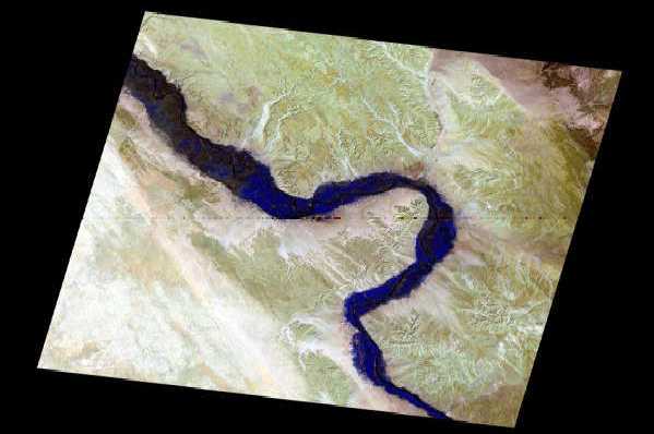
_Nowadays, there is an increasing need for accurate soil spatial data to be easily shared and used between the soil science communities. This study aimed to present the role of remote sensing and geographic information system as effective tools for land use land cover interpretation. The investigated area was a part of Eastern Sohag, Egypt with an area of 204km2. ... Read more

2018-10-31 08:51:20 Keywords spatial variability, soil properties, Remote sensing, GIS,
INTELLIGENT ESTIMATION OF SPATIALLY DISTRIBUTED SOIL PROPERTIES
The physical, chemical and biological properties of the soil are useful for evaluating its fertility, predicting the crop productivity (CIA, 2016). A SOIL HEALTH CARD (SHC) is issued in 2015 in India to a farmer he may enrich his soil for productivity and thus earn more benefits. For this purpose soil survey is carried out to record the crop limiting ... Read more

2018-10-31 08:56:34 Keywords hyperspectral RS, soil properties, Remote sensing, GIS,
DIFFUSE REFLECTANCE SPECRTOSCOPY FOR ASSESSMENT OF SOIL PROPERTIES
uDiffuse Reflectance Spectroscopy (DRS) is important for Qualitative and quantitative assessment of physical and chemical soil properties. uThe accuracy of statistical approaches such PLSR predictions in each of the spectral regions varied considerably amongst soil properties. uA major advantage of DRS for soil analysis is that from a single spectrum many properties may be accurately determined. uBy the application of ... Read more

2018-10-31 09:06:47 Keywords land productivity, Remote sensing, GIS,
Actual and Potential Land Productivity of Some Soils of Sohag-Red Sea Road Sides-Sohag-Egypt
Dear Dr. Ali Refaat Ali Morsy Soil and water Dept., Fac. of Agric., Sohag Univ., Egypt On behalf of the committee of ICAESD 2015, I am pleased to inform you that your abstract entitled: Actual and Potential Land Productivity of Some Soils of Sohag-Red Sea Road Sides-Sohag-Egypt has been accepted as Oral presentation at the International Conference "Agriculture and Environment ... Read more

2018-10-19 12:42:24 Keywords Remote sensing, GIS, Land,
Ph.D. thesis summary
In recent years, the use of remotely sensed data and GIS applications has been found increasing in a wide range of resources inventory, mapping, analysis and environmental management. Remote sensing data provides an opportunity for better observation and systematic analysis of terrain conditions following the synoptic and multispectral and multidate coverage. The present study deals with identification, categorisation and mapping ... Read more

2018-10-24 11:39:09 Keywords Material mapping, Remote sensing, field invest,
Material mapping in the western desert of Egypt using remote sensing and field investigation: a tool for managing urban development
ABSTRACT In the recent years, the Egyptian government and private sector have been interested in developing the desert areas that located between the limestone plateau and the recent flood plain of the River Nile both the east and west sides. These areas represent a corner stone as a source of aggregate materials that used essentially as sub - base materials ... Read more

2018-10-11 19:24:14 Keywords Land use, land cover, Remote sensing,
Utilizing of Geoinformatics for Mapping Land Use/Land Cover Changes in Sohag, Egypt
In this study an attempt was done to assess the change of agricultural land in Sohag province, Egypt between 1987 and 2012. Decision Tree Classifier (DTC) was applied to map land cover changes in the study area. Landsat ETM+ satellite data of three years viz., 1987 and 2012 have been used in the study. Three remote sensing derived indices namely, ... Read more

2018-09-28 21:52:12 Keywords Remote sensing, gold, ETM+,
APPLICATION OF REMOTE SENSING TECHNIQUE FOR GOLD DEPOSITS EXPLORATION IN WADI HAIMUR, EGYPT
This study examines use of Remote Sensing (RS) technology in geology to discover possible exsistence of gold ore deposits in the Wadi Haimur, Egypt. Read more

Meandering and bank erosion of the River Nile and its environmental impact on the area between Sohag and El-Minia, Egypt
The present work deals with meandering and bank erosion of the River Nile of Egypt and its environmental impact between Sohag and El-Minia, Egypt. The study depends on using Landsat imagery acquired on 1987–2000 and field observations. Field observations, remote sensing, and GIS analysis and sinuosity index were used in this study to investigate river meandering and the associated processes ... Read more

2018-08-29 18:11:08 Keywords China, Suichuan, Remote sensing, landslide, GIS, Support vector machines,
Comparison of Four Kernel Functions Used in Support Vector Machines for Landslide Susceptibility Mapping: A Case Study at Suichuan area (China).
Suichuan is a mountainous area at the Jiangxi province in Central China, where rainfall-induced landslides occur frequently. The purpose of this study is to assess landslide susceptibility of this region using support vector machine (SVM) with four kernel functions: polynomial (PL), radial basis function (RBF), sigmoid (SIG), and linear (LN). A total of 178 landslides were used to accomplish this ... Read more

  • «
  • 1
  • »