mostafa.redwan

Mostafa GamalEldeen Taha Redwan

Professor - Professor of Environmental Geochemistry at Sohag Faculty of Science-Geology Department

Faculty of science

Address: Sohag Faculty of Science, Geology dep., P.O. Box 82524, Sohag, Egypt

7

Like

Field and survey geology and field training

2018-08-26 10:32:40 |

Fieldwork course is a vital part of an Earth scientist’s training. It provides a wide range of practical exercises and field experience in geology: observing, measuring, recording, mapping, and problem-solving. Students will do field training throughout the course.  Field geology teaches the basics as to how to make a map when the geology is complicated.  The survey part introduces students to survey measurements of distance, direction and elevations with math review. Survey transverse and triangulation calculations and adjustments including map plotting. Recording field measurements by hand and electronically. Angle measurements using sextants and theodolites, balancing angles; taping, electronic angle and distance measurements, total stations; traverses; coordinate geometry and differential leveling.


Length and Distance Measurement
A chaining party measures a distance AB along a slope with a 100 m. tape which is known to be too long by 0.04 m. The distance from A at the base of the slope to B at the summit is recorded as 416.85 m. Levels run from A to B establish a difference in elevation of 22.50 m. What is the true computed ... Read more

Areas & Land subdivision
A series of offsets were taken at 10 m. intervals from a survey line to an irregular boundary line: 0.0, 3.25, 4.10, 6.45, 8.90, 5.75, 8.50, 0.0 m. Calculate the area enclosed between the survey line and the boundary line by using the _TRAPEZOIDAL METHOD_... Read more

Traversing
1-THE BEARING OF A LINE AB IS N 41° 36'E. THE INTERIOR ANGLE AT B TURNED CLOCKWISE TO THE POINT C IS 72° 36'. THE BEARING OF THE LINE BC IS: (i) N 31° 00'E (ii) N 119°53'W (iii) S 31° 00'E (iv) S 70° 12'W 2- Four interior angles of a five-sided polygon traverse were observed as; A=98° 33' ... Read more

Engineering Leveling
The following consecutive readings were taken with a dumpy level along a chain line at a common interval of 15 m. 1.5, 2.5, 4.0, 2.0, 3.0, 5.5, 1.0, 6.0, and 3.0 m. The first reading was at a reduced level (RL) of 60.5 m. If you know that the fourth and sixth points are turning points. Find the RL o... Read more

Scale
Plot a net (diagonal) scale 1: 600 read till 0.6 m and illustrate on it the reading 11.4 m.... Read more

Calculation of Volumes
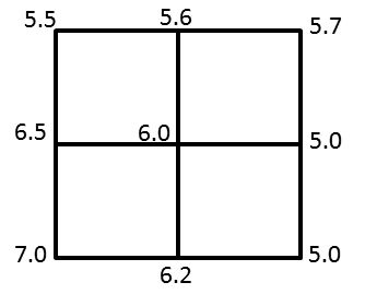
1- Calculate the required _VOLUME OF EXCAVATION_ for the following square area (in the above figure ) to a reduced level of 5.0 meter. Note that the area dimensions are 10 x 10 m. for each square. 2- Calculate the volume of filling for a road cross section its width is 10 m and the height of fillin... Read more

Facebook Group

2018-08-26 11:14:02 Field and survey geology and field training
https://www.facebook.com/groups/642724995897430/?ref=br_rs Read more